Buss Island began with a homeward-bound ship, a storm, and a reported coastline seen beyond the ice. In September 1578, the Emmanuel was separated from Martin Frobisher’s expedition before returning to England with a story of land encountered in the North Atlantic. Almost a century later, John Seller’s detailed chart supplied the supposed island with named harbors and mountains. How had a passing sighting acquired so much shape?
Passenger Thomas Wiars described the encounter in an account printed by Richard Hakluyt in 1589, while an earlier notice had appeared in George Best’s narrative of Frobisher’s voyages in 1578. Both survive in the comparison and reproductions published by Miller Christy in 1897, the edition used here rather than a fresh examination of the sixteenth-century originals. Their differences begin well before Seller drew his coast.
The Buss Comes Home
The Emmanuel was a buss, a small, sturdy type of vessel used in the herring fishery, and the name attached to its reported discovery came from that description. Christy identifies the vessel with Bridgewater in Somerset, while Wiars’s report calls it the Busse of Bridgewater and places it in distress at Bear’s Sound. Strong winds held it near a dangerous lee shore after the rest of the fleet had departed.
Fair weather allowed the vessel to sail on September 3, beginning a passage interrupted by shifting winds before the reported sighting on September 12. At about eleven that morning, Wiars said, land appeared some five leagues away, with a coast the crew estimated at twenty-five leagues in length. They remained within sight until three the following afternoon, when the last visible part lay northwest by north.
Wiars described two apparent harbors along the coast and abundant ice near the land, extending far enough offshore that the vessel did not clear it until September 15. The account then follows the ship homeward to the western Irish coast, sighted near Galway on September 25. It describes a prolonged view from the sea, without recording a landing or an exploration of the interior.
However, Best’s earlier published notice offered a different impression, describing a fertile, wooded country and three days sailing along its coast. Wiars supplied neither the woods nor the fertile interior, and his stated observation lasted part of two days rather than three. Christy emphasized those differences when separating Best’s brief secondhand notice from the passenger’s fuller report, leaving two distinct accounts rather than a single detailed discovery narrative.
An Island Takes Shape
The supposed island entered a North Atlantic already populated on charts by uncertain lands, including Brazil, a name Christy lists among its predecessors. Buss had a particular attraction for navigators because its assigned position lay near routes toward Davis Strait and Hudson Strait. A ship crossing those waters could look for land that earlier voyagers seemed to have described with considerable confidence.
Among the early representations Christy identified was the island on the Molyneux globe of 1592, where it already possessed a complete outline. A different treatment appeared on Hessel Gerritsz’s chart of 1612, which left the northern coast undefined and showed a southern coast with inlets. Christy read that shape as closer to Wiars’s account, since the passenger had described a coast seen in passing rather than a circuit of an island.
Navigators were still trying to reconcile the charts with the sea. James Hall failed to find Buss in its expected position in 1605 and suspected the latitude on the marine charts was wrong, but on his 1606 voyage he reported land that he supposed to be Buss farther west. His changing reports, reproduced by Christy, gave later readers something more complicated than a simple sequence of successful rediscoveries.
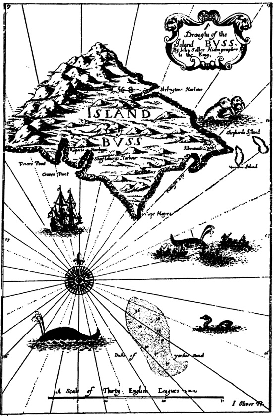
Seller’s presentation added a much more ambitious claim, crediting Captain Thomas Shepherd with a further discovery in 1671 aboard the Golden Lion from Dunkirk. The description reproduced by Christy said Shepherd brought home a map and reported whales, seals, and cod in abundance, with low land to the south and mountains toward the northwest. It also described a fishing bank south of the island, turning the reported coast into a place with apparent commercial possibilities.
Dartmouth catalogs its detailed Seller chart as 1673, and the actual image shows the mountainous island, two smaller islands to the east, and the separate Duke of York’s Sand below. Bays and points carry names associated with Rupert, Shaftesbury, and other prominent figures, while Seller’s title identifies him as hydrographer to the king. The chart’s confident detail went well beyond the coast Wiars had reported seeing from a distance.
Christy’s 1897 study also printed a facsimile of a portion of Seller’s related general Atlantic chart, which is a different view from the detailed Dartmouth image. Comparing the two, he found changed names and the apparent interchange of two harbor labels, alongside names he associated with directors of the Hudson’s Bay Company. The supposed island now had a history on paper as well as a history of sightings.
From Island to Charted Danger
By the eighteenth century, Christy’s survey follows a change from an island that captains hoped to locate to a supposed submerged danger that appeared on charts. Van Keulen’s chart of 1745 carried a description of sunken land and rough water, preserving the place even as confidence in an exposed coastline diminished. The explanation had changed, but the name continued to demand attention from ships passing through the area.
Lieutenant Pickersgill, who had sailed with James Cook, still saw practical promise in rediscovering Buss, suggesting a fishery and a wintering place for northbound ships. Yet he also wrote that the charted danger encouraged seamen to avoid the area rather than investigate it. Christy records his 1776 soundings and the later disagreements about where they had actually been taken.
However, better-documented voyages brought increasingly unfavorable results for the supposed bank. In 1818, John Ross altered course to investigate its charted position, reporting repeated attempts to sound without finding bottom at 180 fathoms, or 1,080 feet. His account, reproduced by Christy, described continuing the search beyond the marked position without locating the expected shallow ground.
William Edward Parry’s expedition tried again in 1819, while physician Alexander Fisher’s account of that voyage described unsuccessful soundings at the assigned locations. Fisher eventually urged hydrographers to remove the supposed remains from their charts at the places investigated. These accounts record failures to confirm a charted bank, rather than observations of an island descending beneath the water.
The Last Speck on the Atlas
Even after such searches, Buss did not vanish from every printed map at once. Writing in 1897, Christy said the latest example he had found was a minute speck in the 1856 edition of Keith Johnston’s Physical Atlas. That was the latest instance in his own survey, not proof of a single year when every chartmaker finally removed the island. Phantom islands could survive on paper long after the sea had been checked. Sandy Island in the Coral Sea, which a 1908 Admiralty chart credited to a sighting by the whaling ship Velocity in 1876, was still in scientific coastline data and Google Earth when a research voyage passed near its charted position in 2012.
Christy favored a different explanation for the earliest sighting, suggesting that the Emmanuel’s crew had encountered southern Greenland without recognizing its position. The proposal required an error in the reported latitude, a difficulty he discussed at length while trying to reconstruct the homeward route. It remains his interpretation of the surviving accounts, rather than an independently confirmed identification of the coast Wiars saw.
The detailed chart survives with its mountains, harbors, and offshore islands, while the separate landmass it portrays has never been established by the records examined here. Wiars’s ship came home, but its reported coast became something later voyagers could neither confidently locate nor simply ignore. Buss Island’s enduring puzzle lies between that first view from the deck and the elaborate shore that followed it onto paper.
Sources
- Miller Christy, On Busse Island, Appendix B, pages 164 to 202, in Danish Arctic Expeditions, edited by C. C. A. Gosch, Hakluyt Society, 1897, Book I. Entire appendix reread through the public scan and transcription. Earlier voyage and Seller passages are cited through Christy’s reproductions, not independently inspected original editions.
- Dartmouth Course Exhibits, Map of Buss Island. Catalog metadata and complete hosted file inspected. John Seller, English Pilot, cataloged 1673.
- Maria Seton, Simon Williams, Sabin Zahirovic and Steven Micklethwaite, Obituary: Sandy Island (1876 to 2012), Eos 94(15), April 9, 2013, pages 141 to 142. DOI. Used only for the Sandy Island comparison.
