The world around us is constantly changing, but few things are more unsettling than the idea that a geographical object that appeared on maps for four centuries can simply cease to exist. Bermeja, an island that supposedly lay off the Yucatán coast of Mexico, has been a mystery that has perplexed researchers, politicians, and fishermen alike. The 80-square-kilometer island first appeared on maps in the early 1500s and was apparently last mapped in 1941, yet when scientists went looking for it in the late 20th century, they found nothing but open water.
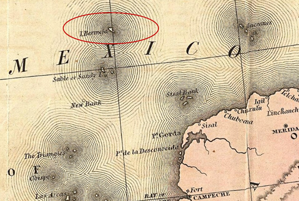
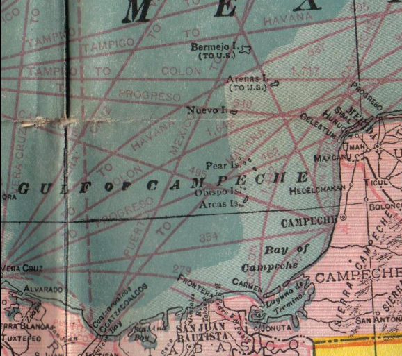
Until recently, the island of Bermeja was believed to sit in the Gulf of Mexico, approximately 200 kilometers off the northwest coast of the Yucatán Peninsula and 150 kilometers from the Atoll Scorpio. Its exact geographical coordinates were listed as 22° 33′ North latitude and 91° 22′ West longitude. It is precisely here that the island of Bermeja was depicted by cartographers from the sixteenth century onward.
Cartographic Origins and Sightings
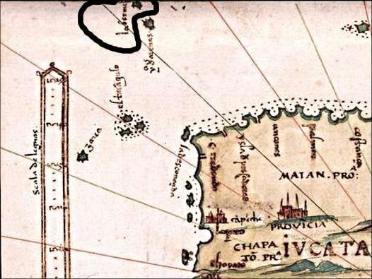
The island was first mentioned by Alonso de Santa Cruz in El Yucatán e Islas Adyacentes, a list of islands of the region published in Madrid in 1539. Its precise location was given in Espejo de navegantes (Seville, ca. 1540) by Alonso de Chaves, who wrote that from a distance, the small island looks “blondish or reddish” – in Spanish, bermeja. The name itself derives from the Spanish word bermejo, meaning russet. Cartographers in the 16th century who placed the island on maps described this reddish or blondish coloration, and since the Spanish word for island, isla, is feminine, the name Bermeja was used instead of the masculine bermejo.
The cartographic depiction of Bermeja Island continued to persist for the next few hundred years. Sometimes the island was spelled as Vermeja Island or Vermejo Islet on maps. There is an island Bermeja on the map of Sebastian Cabot, printed in 1544 in Antwerp, depicted alongside the Islands Triangle, Arena, Negrillo, and Arrecife. The whole of the seventeenth and the greater part of the eighteenth century saw the image of Bermeja remain unchanged. Quite in accord with ancient maps, Mexican cartographers continued to place Bermeja at the same address well into the 20th century.
- The Island of California: An Egregious Error in Cartography
- Hy-Brasil: The Other Atlantis of Irish Legend
The Disappearance and Investigations
In 1997, a Spanish research vessel set out to verify the island’s existence and found no trace of it whatsoever. The question of the loss of Bermeja then engaged the National Autonomous University of Mexico (UNAM). In 2009, another research ship was dispatched to the island’s supposed coordinates. Scientists were unable to find the island or even a trace of it. The UNAM report stated that an analysis of the sea floor at the coordinates 22° 33′ North and 91° 22′ West showed no island had existed at that location, as there were no remnants on the ocean floor to suggest otherwise.
Explanations for its apparent disappearance include an erroneous observation by the early cartographers, shifts in the geography of the ocean floor, rising sea levels, and conspiracy theories [3]. Some hypothesize that natural erosion caused the island to disappear, while more cynical minds have lobbed accusations that the island was deliberately destroyed [1]. French-Mexican cartographer Michel Antochiw Kolpa noted that since 1844, British maps had reported the sinking of the island some 60 fathoms (360 ft; 110 m) below the surface [3].
Political and Economic Implications
The existence of the island would be a critical extension for the maritime boundary of Mexico and would play a significant role in protecting Mexican interests in drilling agreements with the United States. International law allows countries to claim 200 nautical miles of ocean off their territories, known as the country’s Exclusive Economic Zone (EEZ). Currently, Mexico’s Alacranes Islands are the furthest land points that extend into the Gulf of Mexico. The existence of Bermeja Island would have netted Mexico about 15% more territory in an oil-rich area — territory believed to hold 22.5 billion barrels of oil.
“Isla Bermeja was a controversy because it was a key area of the Exclusive Economic Zone in the Gulf of Mexico,” geographer and islands specialist Israel Baxin Martínez explains. “There were official searches around this time to see if there was some remnant of this island because the expansion of this zone for Mexico would mean an abundance of oil”.
The Treaty of 1978 had established an equidistant point between the United States’ Isles Dernieres and Mexico’s Alacranes Islands to set the offshore boundary between the two countries in the Gulf of Mexico — a boundary that would have been redrawn had Bermeja been found.
Conspiracy Theories and CIA Involvement
With such a plentiful stock of black gold on the line, and the complex political latticework that oil negotiations necessarily entail, conspiracy theories about the cause of the island’s disappearance abound. It is even common chatter among fishing communities along the coast of the Yucatán that the island was destroyed deliberately to allow the United States to eat into the Exclusive Economic Zone. The conspiracy theory holds that Bermeja was one of the key reference points used to build the sea border between Mexico and the United States, and that the Americans found it profitable for Bermeja not to exist, since its absence meant that oil and gas fields in the Gulf of Mexico would fall under U.S. rather than Mexican jurisdiction.
Supposedly, the CIA destroyed the island — not recently, but as far back as the 1970s, when satellite images from space began to show a solid water surface in place of Bermeja. The layman’s whisper seeped into political discourse: in November 2008, six senators from the then-governing National Action Party (PAN) raised questions about Isla Bermeja, citing suspicions that the island had been made to vanish deliberately by American powers in order to give the U.S. more leverage in negotiations over marine territory. “It’s a conspiracy theory, of course,” an unmoved Martínez says — but the mystery of Bermeja, an island that appeared on maps for four hundred years before vanishing without a trace, remains very much alive.
Top image: An 1846 map showing “I. Bermeja”. Source: Tanner, Henry S., Library of Congress/ Public domain
By Gary Manners